


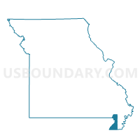
Kennett Ward 2, Dunklin County, Missouri
About
Outline

Summary
| Unique Area Identifier | 607764 |
| Name | Kennett Ward 2 |
| County | Dunklin County |
| State | Missouri |
| Area (square miles) | 1.60 |
| Land Area (square miles) | 1.60 |
| Water Area (square miles) | 0.00 |
| % of Land Area | 100.00 |
| % of Water Area | 0.00 |
| Latitude of the Internal Point | 36.24664110 |
| Longtitude of the Internal Point | -90.04364980 |
Maps


Graphs
Select a template below for downloading or customizing gragh for Kennett Ward 2, Dunklin County, Missouri


Neighbors
Neighoring Voting District (by Name) Neighboring Voting District on the Map
- Independence Rural Voting District, Dunklin County, MO
- Kennett Ward 1, Dunklin County, MO
- Kennett Ward 3, Dunklin County, MO
- Kennett Ward 5, Dunklin County, MO